The geological story of southern Spain
Chapter 4
wrap up
|
To wrap up the framework, opposite is now the full timeframe accompanying the story and its four chapters. As the rocks associated with the various chapters have been formed, incorporated into mountain building, and then partially eroded, what we see around us today is simply the eroded veneer, the polished surface, of what lies many kilometres beneath - up to a depth of 35km or so. A summary map of the geology that is exposed at the surface today is shown below: |

|
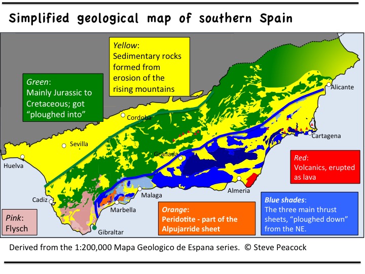
- Internal Betics: South of the blue line, occupying the coastal strip, are rocks comprising what are known as the Internal Betics. The core of the Internal Betics are the Chapter 1 and 2 rocks "ploughed down" from their original position to the NE manifested as three major thrust sheets. Caught up in one of these sheets (the Alpujarride sheet) are peridotites - exhumed fragments of the Earth's lithospheric Mantle.
- External Betics: In-between the blue and green lines are the Chapter 2 rocks that were originally deposited in place here and got "ploughed into" by the Internal Betic thrust sheets. As a result, they too became involved in mountain building, being thrust over each other.
- Flysch: As the Internal and External Betics ploughed forwards, ahead of them at the point of the arc was material scraped off the descending slab and off the advancing overlying plate. This chaotic assemblage of sediments are typically sediments deposited in deepwater and continuously reincorporated and re-deformed during the Oligocene and Miocene.
- "Neogene-Quaternary basins": The yellow rocks represent sedimentary rocks formed from the products of erosion from the rising Internal and External Betic mountains during the Oligocene to Pleistocene. Initially deposited in marine waters around the emerging mountain tops, they have now themselves been uplifted. The Alboran Sea is one of these sedimentary basins that continues to remain below sea-level and receive sediments eroded from the surrounding land.
The next section uses this summary time frame and map as a contextual framework within which to place individual features of geological interest along southern Spain . The blog section gives the opportunity to request geological explanations of your favourite landforms or areas of outdoor activity.
